
Twitter Satellite Constellation Visualization Bot
Published:
NOTE:
This post was intended as the start of a series on how to make a Twitter constellation visualization bot. However, recent updates to the Twitter API have meant that the repetitive nature of the posts have blocked the bot so I will be stopping this effort. I tried to modify my code to work with the new API but it has proved too time-consuming. Instead, I will be posting these GIFs to my personal website on a dedicated page.
Introduction
Inspired by the pioneering work of Jonathan McDowell’s Jonathan’s Space Report and T.S. Kelso’s CelesTrak, I embarked on a journey to create a unique project of my own. Over the Easter holidays, I developed a Twitter bot that provides daily updates on the current state of satellite mega-constellations. While my bot may not match the scale of Kelso and McDowell’s contributions, it’s my modest attempt to make satellite data more accessible and engaging for a broader audience.
Now that I have a working “version 1.0” of this Twitter bot, I’d like to share an overview of its creation process. Whether you’re interested in replicating it, contributing to the code, or simply curious about its inner workings, I hope you find this post informative. If you are curious to see it in action you can check out the Twitter bot here: ConstellationBot
About the Bot
The bot serves as a reliable resource, delivering daily status updates on the largest satellite mega-constellations - at present, it’s tracking the top 7. It’s designed in Python, utilizing the Tweepy library for interacting with the Twitter API. The bot functions autonomously through GitHub Actions and is activated by a cron job that triggers the Python script once daily. Future plans encompass augmenting its competencies with added features and visualizations.
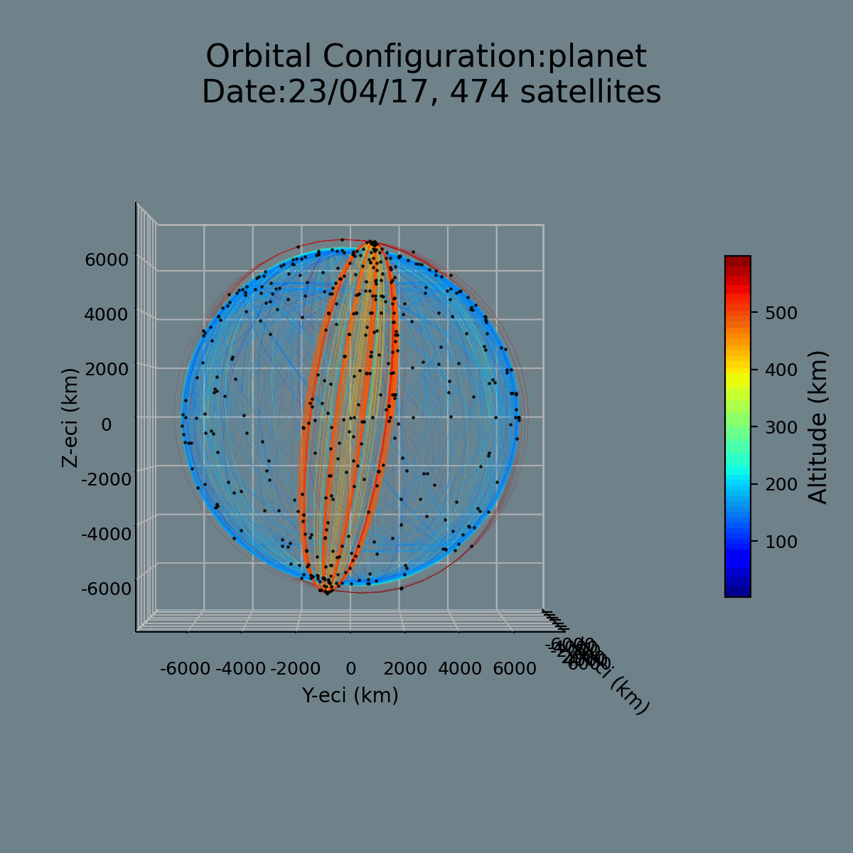
This bot’s mission is to furnish a concise overview of the current state of major players in the arena, expediting the process of staying abreast with the newest advancements. Moreover, it visually illustrates constellation geometry, contributing critical insights into constellation operations such as orbit raising, deorbiting, anomalies, and shifts in geographical coverage. I’m in the process of enhancing a statistics module to accompany each visualization with relevant stats.
The code I share in this post serves only to shed light on the logic that fuels these scripts- I will be sharing the entire code repository in an upcoming post. For now, I hope this will inspire you to dive deeper, and perhaps use this method as a scaffold for you to create your own unique applications.
Method Overview
I will outline a broad overview and share some key functions that I used below.
Selection of Constellations: I chose to track the seven largest operational constellations: Iridium, Starlink, OneWeb, Planet, Spire, and Swarm.
- Fetching Latest TLEs: Fetch the latest TLEs from Space-Track.org. I use the Python package
spacetrackto do this. You will have to make a Space-Track account to use the API to fetch the latest TLEs for the selected constellations. Then you will manually have to do some digging around to find the constellation IDs for each constellation. For the ones I selected this ended up being:constellation_cat_names = {"starlink": "STARLINK", "oneweb": "ONEWEB", "planet": "FLOCK", "swarm": "SpaceBEE", "spire": "LEMUR", "iridium": "IRIDIUM"} Propagating TLEs: Use the Python package
sgp4to propagate the TLEs if required. Two of my visualizations (the constellation geometry and ground tracks), require the state to be propagated forward. I do this for one orbital revolution (or 2pi radians of argument of latitude). The SGP4 propagator will return Earth-Centred Inertial Coordinates in the TEME (True Equator, Mean Equinox) reference frame.import logging from typing import List, Union from sgp4.api import Satrec def sgp4_prop_TLE(TLE: str, jd_start: float, jd_end: float, dt: float) -> List[List[Union[float, tuple]]]: """ Given a TLE, a start time, end time, and time step, propagate the TLE and return the time-series of Cartesian coordinates, and accompanying time-stamps (Modified Julian Day). This is a wrapper for the SGP4 routine in the sgp4.api package (Brandon Rhodes). Args: TLE (str): TLE to be propagated. jd_start (float): Start time of propagation in Julian Date format. jd_end (float): End time of propagation in Julian Date format. dt (float): Time step of propagation in seconds. Returns: list: A list of lists containing the time-series of Cartesian coordinates, and accompanying time-stamps (MJD). Raises: ValueError: If jd_start is greater than jd_end. """ if jd_start > jd_end: raise ValueError('jd_start must be less than jd_end') ephemeris = [] dt_jd = dt/86400 split_tle = TLE.split('\n') s = split_tle[0] r = split_tle[1] fr = 0.0 satellite = Satrec.twoline2rv(s, r) time = jd_start while time < jd_end: error, position, velocity = satellite.sgp4(time, fr) if error != 0: logging.error('Satellite position could not be computed for the given date') break else: ephemeris.append([time,position, velocity]) time += dt_jd return ephemeris- Plotting Positions: You will need to store the (/time series of) positions for each satellite after each TLE is propagated. Then you can use this data to plot the satellite positions in 3D. I use
matplotlibto plot the satellite positions in 3D and I use thecartopymodule for the map under the ground tracks. If you want to plot the ground tracks, you will have to convert the Earth Centred Inertial(ECI) coordinates into Earth Centred Earth Fixed (ECEF)coordinates. Then you will have to convert these to latitude and longitude to project them onto a map of the Earth. Theastropy.coordinatesprovides methods to do both of these conversions accurately and painlessly.- ECI to ECEF: Use the
CartesianRepresentation()class and make sure you convert from GCRS to ITRS. - ECEF to Lat/Long: Use the
Transformer()class to convert from EPSG:4978 to EPSG:4326.
- ECI to ECEF: Use the
Animating Plots: To animate these plots I rotate the plots by 5 degrees about the z-axis and then save each new plot as a numbered frame (.png format ). I then use the
PILmodule to convert the pngs into a gif. For the large constellations this becomes pretty computationally intensive so I have included some use of themultiprocessingmodule to speed things up. This parallelizes the plotting of each frame- however for Starlink this still takes around 30 minutes (and fails in Github Actions)…import logging import multiprocessing as mp import os from PIL import Image import time from typing import Any def generate_geom_gif(const: str) -> None: """ Generate a gif of the geometry of a constellation. Args: const (str): The name of the constellation. Raises: FileNotFoundError: If an image file does not exist. PermissionError: If the program does not have permission to delete an image file. """ const_ephemerides, constellation_img_paths = process_geom_data(const) max_workers = 4 # Max number of processes that can run in GitHub Actions is 5. gif_folder = os.path.join('images/constellation_anim/gifs/', const) images_folder = os.path.join('images/constellation_anim/current_geometry/', const) os.makedirs(gif_folder, exist_ok=True) with mp.Pool(processes=max_workers) as pool: pool.map(create_frame, [(az, const, const_ephemerides, constellation_img_paths) for az in range(0, 365, 5)]) logging.info(f"Combining frames into gif for {const}...") images = sorted([img for img in os.listdir(images_folder) if img.endswith(".png")], key=lambda x: int(x.split('_')[-1].split('.')[0])) with Image.open(os.path.join(images_folder, images[0])) as first_image: image_list = [Image.open(os.path.join(images_folder, img)) for img in images[1:]] first_image.save(os.path.join(gif_folder, f'geom_{const}_{time.strftime("%y_%m_%d")}.gif'), save_all=True, append_images=image_list, duration=110, loop=0) logging.info(f"Finished creating .gif file for {const}") logging.info(f"Deleting frames for {const}...") for img in images: try: os.remove(os.path.join(images_folder, img)) except FileNotFoundError: logging.error(f"File {img} not found.") except PermissionError: logging.error(f"Permission denied to delete file {img}.")Computing Statistics: At this stage, I also compute statistics for the constellation. For the time being this is somewhat rudimentary but it works as follows: I have created a JSON file that contains the number of satellites in each constellation, the number of satellites in each altitude band (from 0-2000 in 100km bands), and the number of satellites in each inclination band (from 0-180 in 10 degree bands), and a timestamp to go with this data. Every time I pull data pertaining to a constellation this JSON file gets populated.
Selecting Statistics: Then I use the
jsonmodule to read the last two entries for a given constellation. I calculate the differences between all the bands and select the largest difference. I then manually generate a tweet that says something like “Starlink has added 10 satellites in the 1000-1100km altitude band since yesterday”.Generating Tweet Text: I pass the statistics and the string with the largest difference along with the name of the constellation to the
openaimodule’sCompletionclass to generate the text. If there is no change in the statistics then I have a different prompt to generate a generic tweet about this constellation.import logging import openai from typing import List, str def generate_tweet(constellation_name: str, viz_type: str, openai_api_key: str) -> str: """ Generates a tweet for the given constellation using OpenAI's GPT-3 API. Args: constellation_name (str): The name of the constellation. viz_type (str): The type of visualization. openai_api_key (str): The API key for OpenAI. Returns: str: The generated tweet. Raises: ValueError: If viz_type is not valid. """ possible_viz_types = ["latest_state", "current_geometry", "ground_tracks"] if viz_type not in possible_viz_types: raise ValueError(f"Invalid viz_type {viz_type}. Must be one of {possible_viz_types}") prompt = create_gpt3_prompt(constellation_name, viz_type) openai.api_key = openai_api_key response = openai.Completion.create( engine="text-davinci-002", prompt=prompt, temperature=0.72, max_tokens=200, top_p=1, frequency_penalty=0, presence_penalty=0 ) # the parameters here took some trial and error tweet_text = response.choices[0].text.strip() tweet_text = "Constellation-bot: " + tweet_text logging.info(f"gpt tweet: {tweet_text}") # If the generated tweet is too short or contains invalid characters, generate a default tweet if len(tweet_text) < 10 or not tweet_text.isascii(): tweet_text = f"Check out the latest state of the {constellation_name} constellation! #spacex #megaconstellations #satellites" if len(tweet_text) > 280: tweet_text = f"Check out the latest state of the {constellation_name} constellation! #spacex #megaconstellations #satellites" return tweet_textPosting Tweets: Finally, I use the
tweepymodule to post the text and the tweet. You will have to set up a Twitter developer account to generate the necessary API keys and tokens to post the tweets. In order to run this script automatically and not have my tokens exposed on Github I have also set up a Github Secret to store these keys and tokens in my repository environment variables.tweepydoes not yet have a build in method to post GIFs so I had to repurpose the code used for posting PNG images. I will make this class available in my repo in the near future.- Automating the process : Finally I set up a Github Actions workflow
cronjob to run the script once a day with a different constellation and visualization type. If the script fails/succeeds I get a notification through the Github app on my phone.
name: Cron twice-daily tweet

on:
  schedule:
    - cron: '0 17 * * *'
  workflow_dispatch:

jobs:
  cron:
    runs-on: ubuntu-latest
    timeout-minutes: 60
    steps:
      - uses: actions/checkout@v3
      - name: Set up Python
        uses: actions/setup-python@v3
        with:
          python-version: '3.8'

      - name: Upgrade pip
        run: pip install --upgrade pip

      - name: Install system dependencies
        run: |
          sudo apt-get update
          sudo apt-get install -y libproj-dev proj-data proj-bin
          sudo apt-get install -y libgeos-dev

      - name: Install dependencies
        run: pip install -r requirements.txt

      - name: Run cron_tweet.py
        run: python source/twitterbot/cron_tweet.py
        env:
          PYTHONPATH: $
          TWIT_CONSUMER_KEY: $
          TWIT_CONSUMER_SECRET: $
          TWIT_ACCESS_TOKEN: $
          TWIT_ACCESS_TOKEN_SECRET: $
          OPENAI_API_KEY: $
          SLTRACK_PWD: $
          SLTRACK_USR: $
As ever if you have any questions or comments please feel free to message me. I hope you enjoyed this post and I hope you enjoy the bot!
